Seitenpfad:
Weblog 11

Chief scientist leg 4
Frank Wenzhoefer
f.wenzhoefer.d at
merian.briese-research.de
Frank Wenzhoefer
f.wenzhoefer.d at
merian.briese-research.de
Where is Maria S. Merian?
Weblog 11
30.11. - 05.12.
30.11.2009
On November 30 the AUV-team continued with their success story. AUV-dive 27 was the longest mission possible. After 9 hours and 39 km of survey the AUV returned to surface with almost empty batteries. Half way to the surface the battery capacity was then too low to keep the communication available and the vehicle solely surfaced with its positive buoyancy. However, during its dive the AUV mapped the northern, western and southern rim of the mud volcano and thus we have covered almost the entire geostructure, only a small area in the eastern part is missing. The bathymetry map revealed that the Amsterdam mud volcano is a complex structure with a rough center, a smoother outer area towards west, surrounded by a rough rim. The high-resolution data enable as also to identify single structures.
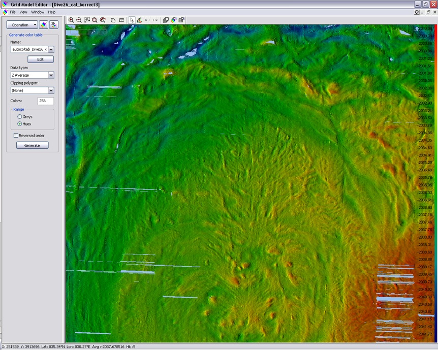
Fig. 1a : 2-D Bathymetry map of the center and north-west area of the Amsterdam mud volcano; 0.5 m raw-Grid, single filtering (Source: Marum, Bremen)
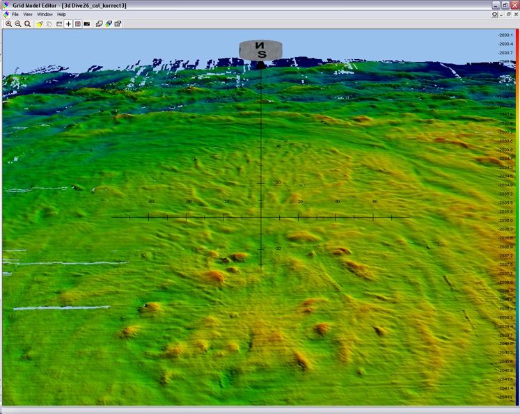
Fig. 1b: 3-D view of the center area; 0.5 m raw-Grid, single filtering, scale increments 10m (Source: Marum, Bremen)
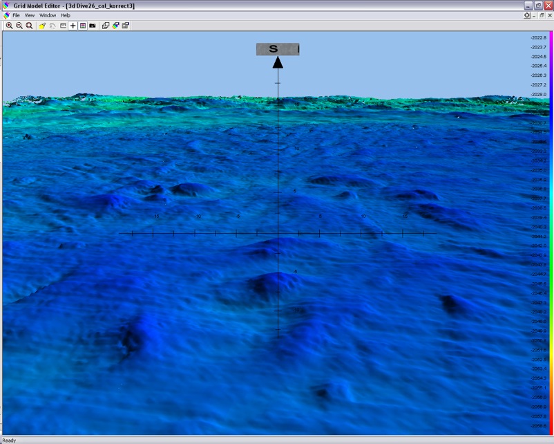
Fig. 2a Detailed 3-D image of the seafloor structures in the mud volcano canter; 0.5 m raw-grid, single filtering, scale increments 2.5m (Source: Marum, Bremen)
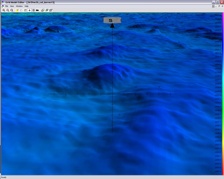
Fig. 2b: Detailed 3-D image of a single geostructure; 0.5 m raw-grid, single filtering, scale increments 1m (Source: Marum, Bremen)
ROV dive 257 was only short and had to be stopped at 500m water depth. The manipulator still does not work properly; another night of repair for some of the pilots. We used the time to take a TV-MUC sample from the surrounding area to get a reference sample. We choose a site with a normal sediment temperature profile but during the TV-MUC survey several black patches were visible indicating that this site is still influenced by the mud volcano activity.
On December 1 during ROV dive 258 we were then able to collect sediments from the mud volcano center. Large patches of grey sediments, even sometimes with small white bacterial mat patches, covered this part of the mud volcano. Using our Lift to bring additional instruments to the seafloor, like the benthic chamber and blade corers, we were able to collect samples for all groups on board.
The next two days were characterized by bad weather preventing any AUV or ROV dive. Thus these days were used to perform additional heat flow measurements, which will help us to better define the active area of the mud volcano. Further Parasound transect were used to map the gas flares since Miriam Römer found out that the seeps were not constantly emitting gas but showed some periods of quietness. In total 34 flares could be detected by Miriam clustering in three sites. Besides the strong flares seen, which often reach up to 750m into the water column, several weaker flares, extending between 100 and 500 m into the water column were detected.
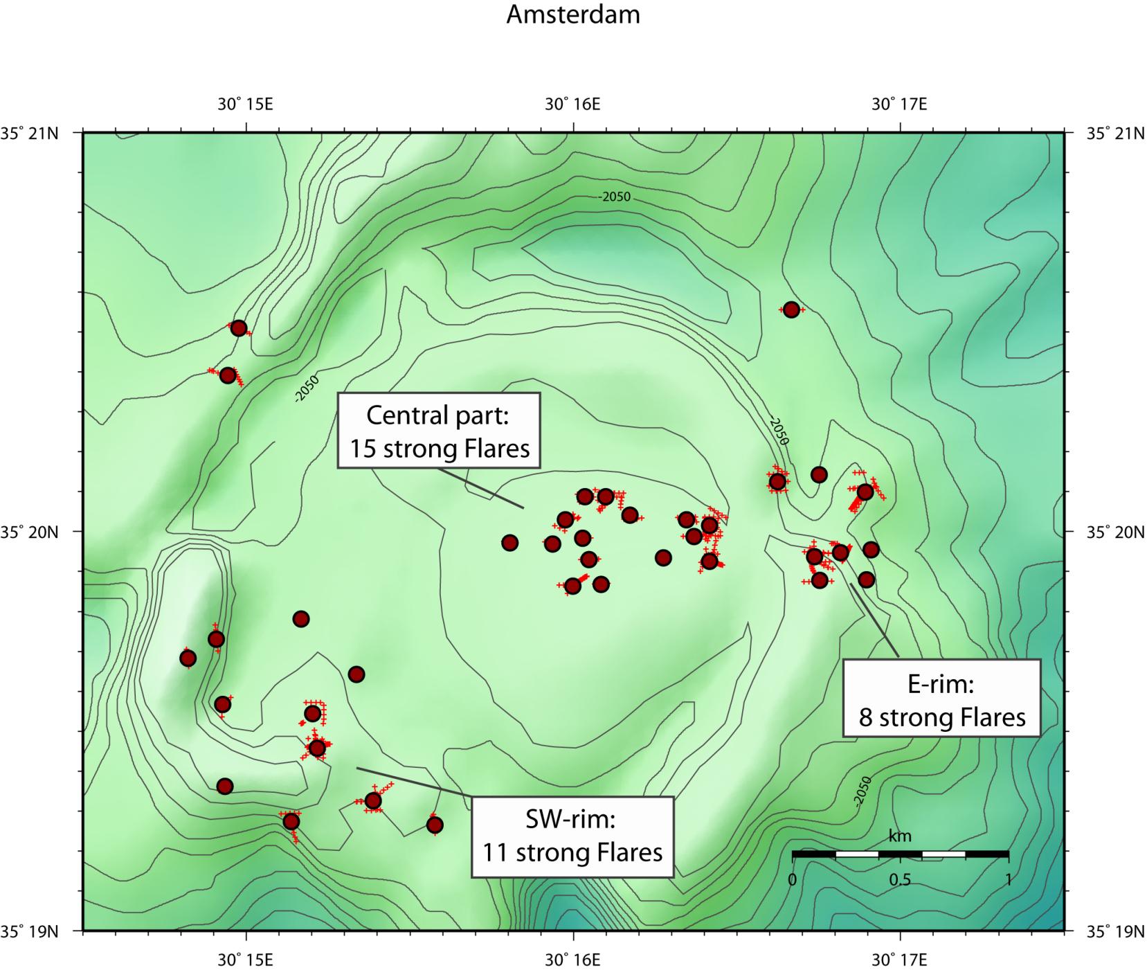
Fig 3: Distribution of gas flares at the Amsterdam mud volcano (Source: Miriam Römer, Marum Bremen)
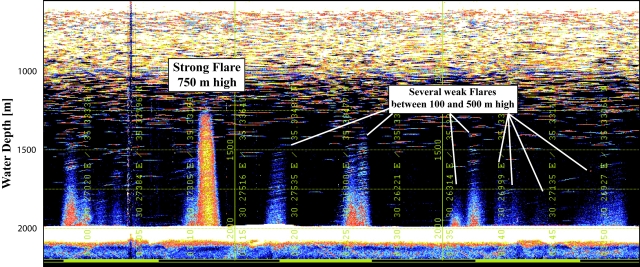
Fig 4 Screenshot showing several flares extending in to the water column (Source: Miriam Römer, Marum Bremen)
On December 4 we once again deployed our lift system packed with several in situ tools to take samples from the sediment areas between the grey and black sediment patches. The idea was to compare the geochemical zonation, benthic fluxes and fauna (from micro to marco) composition from the different habitats. However, ROV dive 259 had to be aborted due to technical problems with the ROV. After recognizing that the ROV-team needs a longer time period to repair Quest, the Lift was released and recovered.
The evolved time was then used to map the mud volcano Athina with Parasound for gas flares and to perform a TV-MUC transect to search for gas emitting sites and to map the habitats. A strong flare at in the center of Athina was found by Parasound and TV-MUC.
The evolved time was then used to map the mud volcano Athina with Parasound for gas flares and to perform a TV-MUC transect to search for gas emitting sites and to map the habitats. A strong flare at in the center of Athina was found by Parasound and TV-MUC.
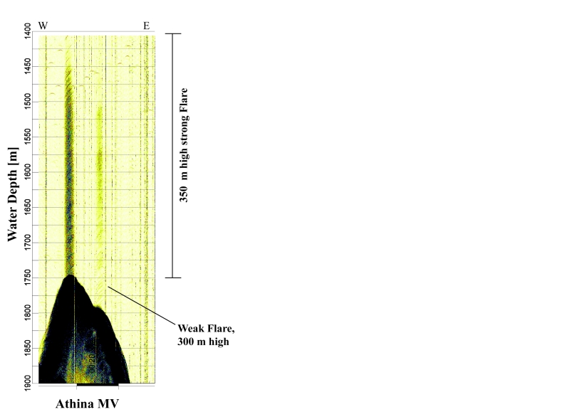
Fig. 5: Parasound image showing a strong flare at the center as well as a weak flare at the rim (Source: Miriam Römer, Marum, Bremen)
Since the weather situation improved on December 5 and the repairs on Quest were finished another last dive on Amsterdam was planed to recover the colonization experiments and Homer Beacon placed two weeks ago during our first ROV dive. Unfortunately the dive had to be aborted again at 500 m water depth due to technical problems and thus we have to leave the instruments at the seafloor for longer. The remaining time before we have to leave the working area the next day was used with Parasound mapping of the Thessaloniki and Kula mud volcanoes.
Frank Wenzhöfer